Two months of the annual southwest monsoon are over, with another two to go. As against a normal rainfall of 452.8 millimetres (mm), the country has received 426.1 mm rainfall, thereby registering a rainfall departure of minus 6% till July 31.
As per India Meteorological Department (IMD), if the “percentage departure of realised rainfall is within 10% of the long period average,” it is considered ‘normal’ rainfall. The long period average is calculated on the basis of mean rainfall in the four months of southwest monsoon from 1951 to 2000 and works out to an average of 89 cm for the country as a whole.
In spite of the seemingly ‘normal’ monsoon scenario in the country, some states are braving floods, whereas others are preparing for drought. Interestingly, states such as Gujarat are dealing with both the disasters because of wide spatial variation in rainfall within the state. For instance, Gir Somnath district in Saurashtra has received 128% of its normal rainfall till July 31, whereas Gandhinagar district has recorded ‘large deficient’ rainfall of minus 64%. Kutch region in the state has minus 75% large deficient rainfall, too. Ahmedabad, Surendranagar, Patan and Mehsana districts have deficient rainfall of minus 56%, minus 58%, minus 52% and minus 48%, respectively.
Just two weeks ago – in mid-July – several districts in Saurashtra and south Gujarat were braving terrible floods. Villages were cut off and a number of roads, including two national highways and 12 state highways, were closed. Because of continuous heavy rainfall and floods, 52 people lost their lives in Gujarat.
“The recent floods in Gujarat show that deficient rainfall and floods is a matter of scale and depend on time and space; when it rains and where it rains is important,” said Vimal Mishra, associate professor of civil engineering at Indian Institute of Technology, Gandhinagar. “These events of extreme rainfall reflect the changing characteristics of our summer monsoon rainfall,” he added.
When it rains and where it rains
Picture this: Till July 9, Gir Somnath district in Saurashtra had ‘large deficient’ rainfall (ranging between minus 99% and minus 60%). By July 16, with 83% of its normal rainfall, Gir Somnath had jumped to ‘large excess’ rainfall category (rainfall above 60%). And, within another day, by July 17, it had received 158% of its normal rainfall leading to extreme floods.
Similarly, within a day, between July 17 and July 18, Devbhoomi Dwarka district jumped from ‘large deficient’ rainfall of minus 82% to ‘normal’ rainfall category. Porbandar and Jamnagar, which were reporting deficient rainfall of minus 57% and minus 38%, respectively, also moved to normal rainfall category within a day. Meanwhile, as of July 31, Devbhoomi Dwarka district is back to ‘deficient’ rainfall category with minus 29% rainfall departure.
Assam and Manipur in the northeast faced similar situation in the month of June, when both the states were under deficient rainfall category, but were also facing floods. Uttar Pradesh, with minus 20% deficient rainfall till July 29, is now braving floods and over 49 people have been killed in the state due to heavy rainfall.

Rains or the lack of it have wrecked havoc in various parts of the country in 2018. Photo by Nidhi Jamwal.
Over 537 people have lost their lives this southwest monsoon season (2018) due to heavy rainfall and floods in six states of the country.
Looking beyond the regular statistics
According to M. Rajeevan, secretary, Union Ministry of Earth Sciences, the monsoon season consists of two large modes of variability. “One is spatial mode in which on a given year all the sub-divisions may not get equal amount of rainfall. When central plains get rains well, normally the northeast region receives less rainfall,” he explained. As of July 31, all sub-divisions in the northeast are in deficient rainfall category.
The second variability is on time scale. “We do not receive rainfall on all the days and there are active and break spells … Gujarat is well known for short spells of heavy rainfall, which has implications for water management,” added Rajeevan.
To understand spatial variation in monsoon rainfall and the co-existence of deficient rainfall and floods, it is important to look beyond the regular statistics, said R.R. Kelkar, former director general of IMD. More than the total quantum of rainfall, it is the timing of rainfall that matters. “Disasters such as floods and droughts are not related to the total rainfall, but the timing of the rainfall,” he said.
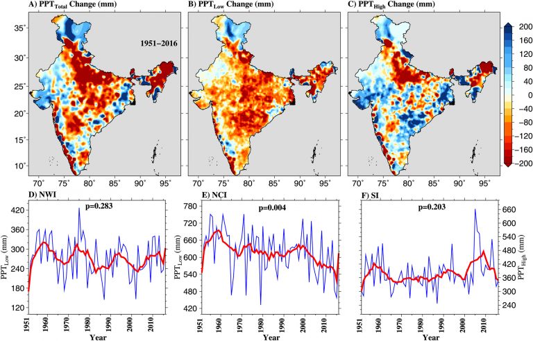
Recently, a May 2018 study reported that the intensity of monsoon precipitation is changing, which has implications for droughts, floods and groundwater recharge in India. Authors of the study, Mishra and two more researchers, have estimated long-term (1951-2016) changes in total monsoon precipitation, low-intensity precipitation and high-intensity precipitation in the country.
Map showing the changes in precipitation characteristics over India. Image from Asoka et al 2018 (Asoka, A., Wada, Y., Fishman, R., & Mishra, V. 2018, Strong linkage between precipitation intensity and monsoon season groundwater recharge in India, Geophysical Research Letters)
The results show “substantial decline in total precipitation (PPTTotal ) and low-intensity precipitation (PPTLow) across India”. But, within the same time period, the study found high spatial variability in the trends of PPTHigh [high-intensity precipitation] over India. For instance, high-intensity precipitation has increased in western and peninsular India, and declined in the Indo-Gangetic Plains, finds the study.
“Our analysis shows that low-intensity rainfall is declining in Gujarat and high-intensity rainfall is on the rise in the state. Meanwhile, overall rainfall has declined in the Indo-Gangetic Plain,” said Mishra.
As of July 31, Bihar and Jharkhand have a rainfall departure of minus 23% and minus 24%, respectively. The Bihar government is already preparing for drought and has announced measures for kharif sowing and diesel subsidy to the farmers. Threat of drought looms large over northeastern states, which are facing deficient rainfall. Manipur has recorded minus 64% rainfall departure.
Dry spell ahead?
While parts of Gujarat are braving floods and Bihar is preparing for drought, the multi-modal and multi-ensemble (MME) extended range forecast of IMD is suggesting reduced rainfall and a break in monsoon starting July 27, which may extend till August 23 in some states of the country, such as Maharashtra.
“Yes, from July 27 we expect weakening of monsoon, but for a short period. We should ultimately receive normal rainfall, as we predicted,” said Rajeevan of MoES.
However, Kelkar claims that the terminology of ‘normal’ rainfall is misleading, as it averages out downpour in high-rainfall and low-rainfall areas. “Thus, the country and its various states end up getting ‘normal’ rainfall, which is far removed from the ground realities,” he said.
According to Kelkar, dry spells are a part of the monsoon. “Wet spell cannot sustain for 120 days of the southwest monsoon. After a wet spell, dry spell will come and is normal. What is of concern is the duration of dry spell, which isn’t easy to forecast,” said Kelkar. “An extended dry spell can have bad impacts on the kharif crops,” he added.
In the month of June, a prolonged dry spell delayed kharif (monsoon crop) sowing in several states of the country. Although the sowing has now picked up, it is still 7% lower than last year. And, the break in monsoon could make things worse.
On August 1, Skymet Weather, a private forecasting agency, updated its monsoon forecast for this year to 92% of long period average, which is below normal rainfall. Earlier this year, the private agency had predicted normal southwest monsoon with 100% rainfall of the LPA with no chance of drought in the country.
“If dry spell extends in Marathwada [Maharashtra] till third week of August, then it will badly impact the kharif crops,” said Mohan Gojamgunde, an agricultural officer at Latur in the Marathwada region. “We have 80% kharif area under soybean in Latur and Osmanabad districts. A prolonged dry spell, of more than 10 days, will affect soybean growth and flowering, and lead to yield losses,” he added.
El Niño: Is it a concern for India’s southwest monsoon?
Meanwhile, meteorologists across the world are keeping a close watch on El Niño, a complex weather pattern resulting from variations in ocean temperatures in the equatorial Pacific. As per the El Niño Watch, issued on July 12 by the US-based National Weather Service Climate Prediction Centre and the International Research Institute for Climate and Society, there is “the chance for El Niño increasing to about 65% during fall, and to about 70% during winter 2018-19”.
A large number of scientific studies associate El Niño with a weak southwest monsoon (rainfall below normal) and La Niña with a strong southwest monsoon (rainfall more than normal).
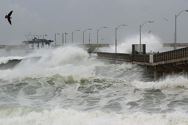
El Niño waves crashing against a pier. Credit: Jon Sullivan/Wikimedia Commons
However, experts’ opinion on the impact of El Niño on this year’s southwest monsoon is divided. Whereas a section of meteorologists believe El Niño may impact the latter part of the monsoon [rainfall in September], others claim it is too early to comment on its fallouts.
“Scientists are quick to link El Niño and Madden-Julian Oscillation [MJO] with the southwest monsoon. But forget that our monsoon is a global annual feature and has its own system and its own strengths,” said Kelkar. According to him, there are a number of local factors, such as the Tibetan Plateau, the Indian Ocean and the Bay of Bengal that have more influence on the monsoon than El Niño or MJO. “No one talks about impact of the almost five kilometre tall Tibetan plateau on the southwest monsoon, as it is near impossible to get last 100 years data about the plateau,” he complained.
According to Sridhar Balasubramanian, associate professor of mechanical engineering and an adjunct faculty in IDP Climate Studies at the Indian Institute of Technology Bombay, the Bay of Bengal plays an important role in the southwest monsoon, which is still not fully understood. “As per our research paper, published in April this year, the inter-annual variability of the Bay of Bengal is very high for a normal monsoon year in comparison to an El Niño year,” he said.
Inter-annual variability of Bay of Bengal refers to its dynamical state each monsoon year, which is extremely crucial for genesis and sustenance of low pressure systems and tropical depressions. Due to the high inter-annual variability during normal monsoon years, the dynamical state of Bay of Bengal every year is very different, thereby causing erratic rainfall pattern across India. However, during El Niño and La Niña years, the variability is low, and hence the dynamical state of the Bay is more or less the same leading to a more consistent rainfall pattern, explained Balasubramanian.
“The fundamental physics behind high inter-annual variability of normal monsoon years is not very well understood and is an ongoing topic of research,” he added.
Scientists have started taking a keen interest in the connections between the Bay of Bengal and summer monsoon intra-seasonal oscillations (MISO). The MISO is a process that occurs several times each year from May to October in the atmosphere over the tropical Indian Ocean, the western tropical Pacific Ocean, and the surrounding land areas. MISO events alternate between periods of wetter-than-average and drier-than-average conditions, a cycle that lasts longer than typical weather systems do (1-2 weeks), but shorter than a season (90 days). MISO, it is believed, come from some kind of powerful atmosphere-ocean interaction.
As part of a five-year study on the relationship between MISO and the Bay of Bengal, known as MISO-BOB (partially funded by the ministry of earth sciences), a group of researchers is already studying the atmosphere-ocean interaction in the Bay of Bengal to unravel mysteries around our monsoon.
This article was originally published by Mongobay. Read the original article here.


