Fact Check: Ram Mandir Is Being Built at the Same Site Where Babri Masjid Once Stood, Not 3 Km Away
The Ram Mandir-Babri Masjid controversy, which is a dispute over a 2.77-acre piece of land in Ayodhya, Uttar Pradesh, between Hindus and Muslims, reached its climax in 1992 when a large group of Hindu activists associated various right-wing organisations, such as the Vishwa Hindu Parishad, demolished the Babri Masjid, triggering communal riots. The legal battle over the dispute finally culminated in November 2019, when the Supreme Court permitted the construction of a Ram Temple in Ayodhya, at the site where the 16th century Babri Masjid once stood, and in the same order, asked the UP government to allot a five-acre plot in Ayodhya for the construction of a mosque.
Construction work for the temple began in August 2020 and is yet to be completed. The consecration of the idol of the Hindu deity Ram will be held in the sanctum sanctorum of the semi-constructed temple on January 22. Against this backdrop, a screenshot of Google Maps has gone viral on social media with the claim that the temple is not located at the site where the Babri Masjid once stood or on the parcel of land over which the two communities have disputed for decades. It is claimed that the Ram Mandir is actually being built 3 kilometres away. Several politicians have also promoted this claim.
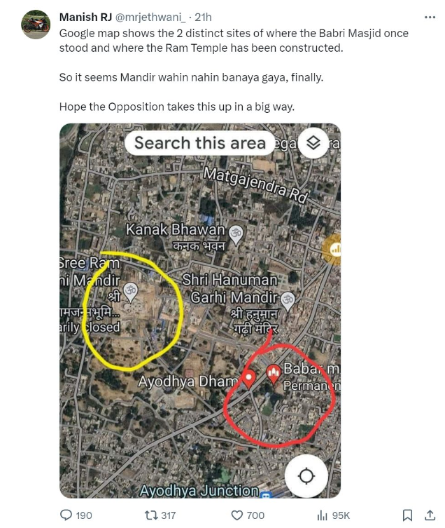
A user named Manish Jethwani tweeted the Google Maps screenshot in which two locations were circled. One of these signified the temple being built in Ayodhya, while the other read ‘Babar Masjid (permanently closed)’. While sharing this, the user claimed that the Ram Mandir was not being built at the site where the Babri Masjid was demolished, but at another location. (Archived link)
Haryana Pradesh Congress general secretary Vikas Bansal tweeted a statement by Shiv Sena leader Sanjay Raut and wrote that Lord Rama was born at the site where the Babri Masjid was built and that is why it was demolished. He questioned why the temple was being constructed 3 kilometre away. He also questioned why the mosque was demolished and Hindu-Muslim tensions flared if the Ram Mandir was planned to be constructed 3 kilometres away. (Archived link)
"मंदिर वही बनाएंगे" "मंदिर वही बनाएंगे" बोल बोल कर बाबरी मस्ज़िद गिराई। बाबरी मस्जिद के बड़े गुंबज के नीच ही भगवान श्री राम लला का जन्म हुआ था इस लिए वही मंदिर बनाने के हेतु से मस्जिद गिराई गई। फिर मंदिर वहा से 3 किलोमीटर दूर क्यों बनाया जा रहा है? अगर 3 किलोमीटर दूर ही मंदिर… pic.twitter.com/rNvmkhvuaU
— Vikas Bansal (@INCBANSAL) January 15, 2024
News 24 also tweeted Raut’s statement. (Archived link)
Muslim ‘scholar’ Fazeel Ahmed also said in an interview that the Ram Temple being built in Ayodhya was located 3 kilometre away from the place where the Babri Masjid had been demolished. (Archived link)
मंदिर वहीं बनायेंगें..
अगर ये ख़बर सही है, तो बताओ तुम्हें क्या मीला ?
देश की एक इतिहासिक धरोहर ख़त्म कर के..👇 pic.twitter.com/wMTLNJ3Dhw— 𝕀𝕟𝕕𝕚𝕒𝕟 (@khan_00555) January 15, 2024
Fact check
We checked the area marked in yellow on the viral image and found that this was indeed the site for the under-construction Ram Mandir. To find out more about the other site (circled in red in the viral image), we searched it on Google Maps and found that a Birla Temple dedicated to Hindu deities Ram and Sita existed at this location in Ayodhya. In addition, the below graphic contains a side-by-side comparison of the viral screenshot with what we found on Google Maps. It is worth noting that the structure seen in the satellite image on Google Maps, when zoomed in, matches the Birla Temple exactly. This means that this location has the Birla Temple.
It is worth noting that in the viral image, the red-circled site is marked as ‘Babar Masjid’, and not Babri Masjid. When we searched Google Maps to gather more information related to this, we found that the Birla Temple itself had been wrongly marked, and a picture of the Babri Masjid had been uploaded.
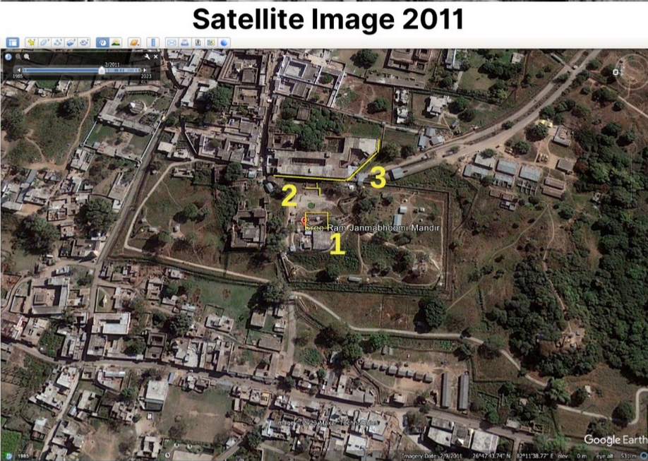
In addition, Alt News searched for the Shri Ram Janmabhoomi Temple being built in Ayodhya on Google Earth Pro. We found that in the latest satellite image taken in 2023, a temple-like structure can be seen at this location. After this, we looked at the old satellite images of the same site with the help of the Google Earth Pro application. Among the old pictures, we found the clearest one from 2011,Babri which shows that the construction of Ram Temple had not begun at the time. The coordinates of this location are (26°47’43.74″N 82°11’38.77″E).
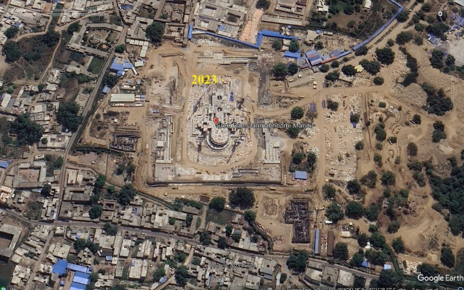
2023 satellite image (Ram mandir under construction)
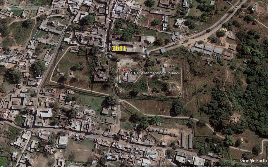
2011 satellite image (No construction)
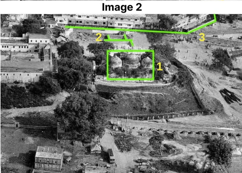
We looked up the internet and found several pictures of the now-demolished Babri Masjid. In two of these photographs shot from two opposite sides of the mosque (Image 1 and Image 2 below), the Babri Masjid and some unidentified structures are visible, and in only one (Image 2), a sprawling building nearby can be seen. We matched these with the satellite image from 2011.
The part marked as 1 is the Babri Masjid. This is visible from two sides in Image 1 and Image 2. The structure marked as 2 in Image 1, Image 2 and Satellite Image from 2011 below is a concrete plinth beam-like structure adjacent to a building close to the Babri Masjid. The building marked 3 is also visible in Image 2 and the 2011 satellite image. In this way, when we compare the structures present in Image 1 and Image 2 with the satellite images from 2011 and 2023, we can see that the Ram Mandir is being built at the same site where the Babri Masjid once stood.
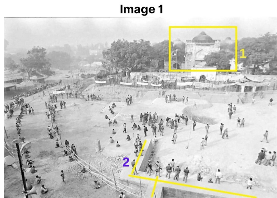
To sum up, several social media users, including Shiv Sena leader Sanjay Raut, have falsely claimed that the Ram Mandir is being built 3 kilometres away from the site of the now-demolished Babri Masjid. In reality, the Ram Mandir is being constructed at the same site where the Babri Masjid once stood.
This article was originally published on Alt News.
This article went live on January eighteenth, two thousand twenty four, at twenty-five minutes past ten at night.The Wire is now on WhatsApp. Follow our channel for sharp analysis and opinions on the latest developments.


